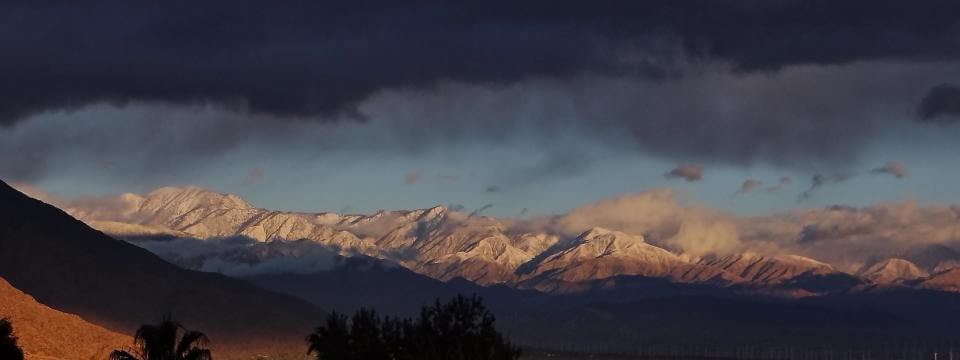
Summiting San Gorgonio is the dream of any adventurous hiker. Being the highest peak in Southern California, the climb to San Gorgonio Peak is the biggest test of a hiker’s endurance and will.
Standing tall at over eleven-thousand feet, it is also one of the most beautiful peaks in the region. There are several trails that take you to the summit, however, the route via Vivian Creek is perhaps the most rewarding in terms of magnificent views, difficulty, and adventure.
Important Facts to Know Before You Go
San Gorgonio has been historically nicknamed ‘old greyback’ mainly because it adorns an eye-catching rounded grey peak. Most of the trail on the upper side of the mountain is barren and rocky.
The Vivian Creek trail is the fastest route that takes you to the summit. It takes about ten strenuous hours of hiking to get there. Many people have completed the hike in a day, and if you prepare and train well then you can do it too. However, you always have the option of splitting the hike over a span of two days and take rest at High Creek Camp.
Trail Highlights
Trailhead location: Google Maps
Trail type: Out and Back
Trail Map: San Gorgonio Trail Map
Total distance: 18.5 miles
Hike time: 10 hours
Highest elevation: 11,503 feet
Net elevation gain: 5,470 feet
Trail condition: Good Overall
Preferred season: June to October
Pets: Yes (with or without leash)
Parking pass: Parking Fee
Permits: Voluntary Permit
Park Contact: Mill Creek Visitor Center
Current weather: National Weather Service
Trail Conditions
The Vivian Creek Trail is an out-and-back trail. It is a difficult hike, to say the least, and is recommended only for hikers who have adequate experience. None of the other hiking trails are as steep as this one, which is also why it is the quickest way to reach the summit.
It can be broken down into five distinct sections for convenience. The first part of the trail is quite gentle; you make your way through densely forested Mill Creek Canyon. The next part is mainly a steep mile of switchbacks which cover around a thousand vertical feet. The third part of the trail goes along a muttering Vivian Creek. You will cover this part with some ease.
The fourth section will get a little steeper and you should remain wary of altitude sickness because this is where you cross the ten-thousand feet mark. The final part of the trail is a steady climb to the summit. There is not much vegetation and your hike from here on will be under the heat of the sun.
How to Get to Vivian Creek Trailhead?
Take Exit 80, when coming from I-10, for University Avenue and make a right turn. Continue on the road for a mile and take a right towards CA-38. Travel eastward for about twenty miles (You will pass Mill Creek Ranger Station on the right) and then take a right turn for Valley of the Falls Road.
From here, keep going for another four miles to reach Big Falls Picnic Area Entrance. Park your car at the eastern end near the Vivian Creek Trailhead (You will require an Adventure Pass).
Key Trail Directions and Landmarks
- Exit the Parking Lot, and look for the hiking boards to see where the hike starts.
- There are trail signs that will guide you along the start of the trail to make sure you do not lose your way.
- As you hike on a rocky road, you will see a sign that points towards Mill Creek.
- Cross the creek, and join the Vivian Creek Trail.
- The first phase is a tough ascent, take your time. You will enter San Gorgonio Wilderness as the trail begins to gentle down.
- When you are 3.3 miles into the trail, stay left and turn towards High Creek.
- You will reach High Creek Camp after hiking more than 2.5 miles.
- Cross the stream at High Creek and gradually make your way up the switchbacks.
- Next, you will reach a ridge; follow the trail to the left.
- The vegetation gets sparse in the last part of the trail. It gets pretty steep too.
- Look for cairns if you start to get lost at this point.
- There is a sign at the summit. Make sure you take a memorable photo with it to mark your successful hike!
Vivian Creek Trailhead Parking
You will need a National Forest Adventure Pass to get hassle-free entry into the parking lot. It is quite small in size and hence, fills up quite quickly. There is however a larger lower parking space down the hill in order to accommodate the excess of vehicles there.
Vivian Creek Trailhead to Vivian Creek Campground
The trail starts off gently, but speedily changes to an exhausting climb. As you make the ascent you will shortly reach the first ridge passing through Vivian Creek Campground. The trail is very well-forested and makes it a wonderful outdoor experience.
Toward High Creek Campground
The trail from the campground is really beautiful especially since it meanders along with the creek. The creek combined with the dense forest makes the hike uplifting and refreshing at this point.
You will have to keep with the trail, and avoid the trail that goes left from the creek. Cross the creek, and climb up the rocks ahead to reach a junction that leads to a number of different campsites.
High Creek Campground: The Last Campground
This campground is the last one and also the last water source for you before the summit. You should not, however, rely on the High Creek for water for it can easily go dry in the summers which will leave you in a lot of trouble. Pack lots of water before you start your journey.
The trail from here mainly consists of a number of switchbacks. The temperature can rise because of the lack of forest cover. (Quick Tip: Make an early start to avoid hiking under the sun’s scorching rays)
Reaching Sky High Trail
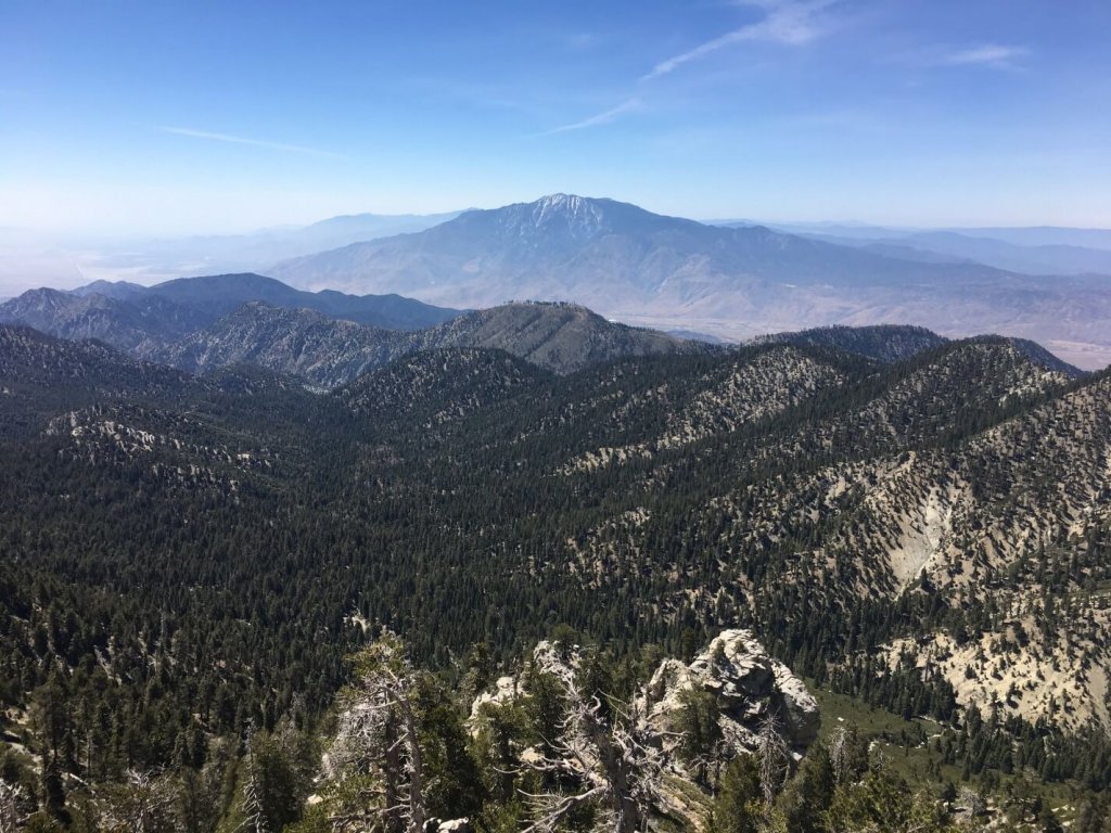
You will tread along the trail as it kisses the ridge. You will have the chance to witness some glorious views of Mt. San Jacinto and the Inland Empire from up here. There will be a lot of sun, so be sure to apply some sunscreen.
The Sky High Trail will join this trail from the south, just head east to reach the summit.
San Gorgonio Peak
You are overcome with 360-degree views as far as the eye can see. It is a great place to enjoy some lunch and take some rest before heading back down. Cherish the moment; you just hiked the highest peak in southern California. Take some time to absorb it all in!
Retrace your steps to get back to the trailhead parking.