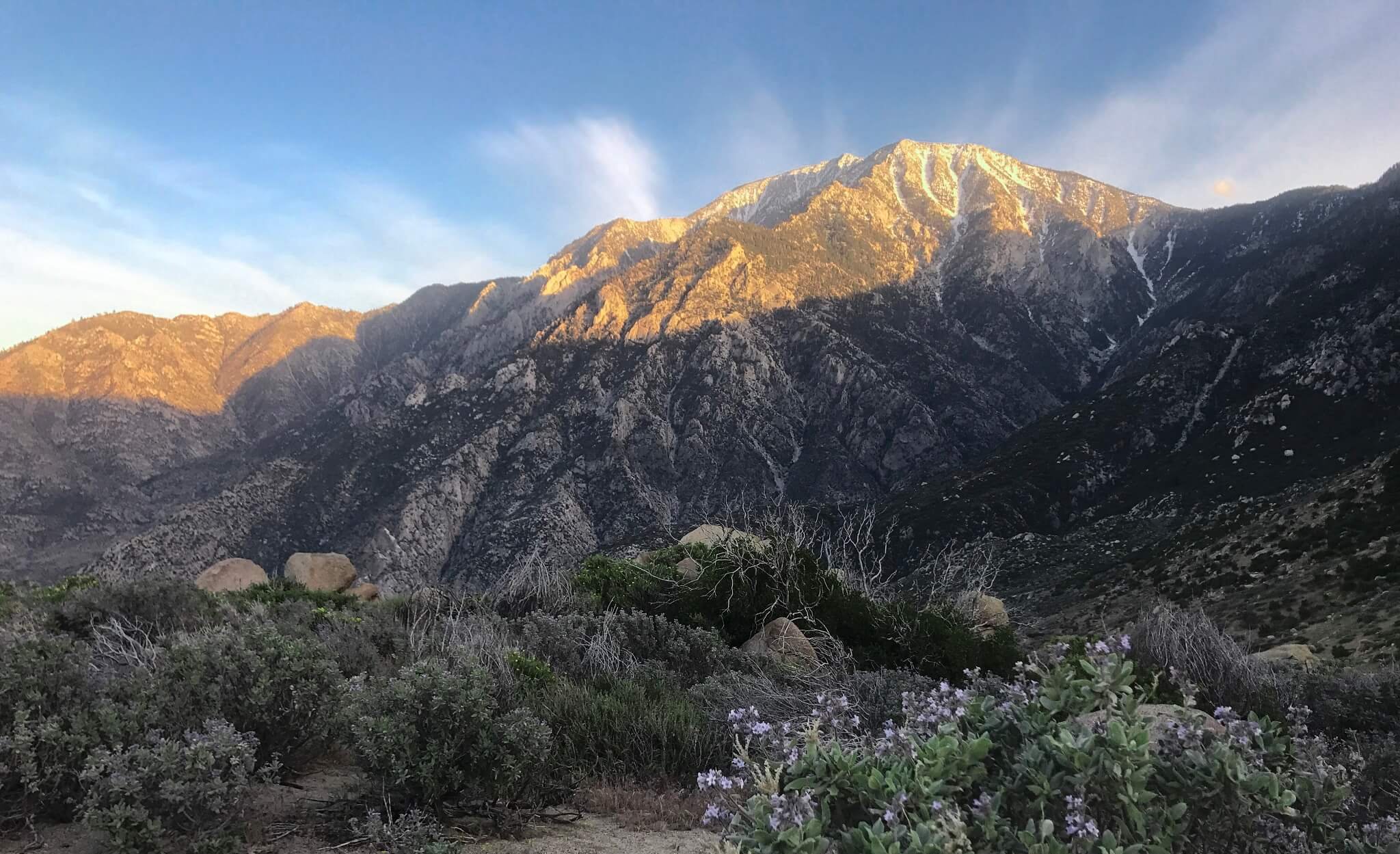
The second highest peak in all of Southern California and the highest of the San Jacinto Mountains, Mount San Jacinto is the ultimate attraction for any hiker in these parts of the United States.
The summit brags one of the most wondrous and enchanting views any person can imagine. And, nobody puts it more beautifully than the famous naturalist John Muir who called the view from Mt San Jacinto ‘the most sublime spectacle to be found anywhere on this earth’.
Important Facts to Know Before You Go
There are several routes that you can take when summiting Mount San Jacinto for example, the popular tram route from Palm Springs. However, if you are a hiker who is looking for a more exerting and challenging trail route then the one via Marion Mountain holds a lot of promise. It starts just a few miles north of Idyllwild.
Hiking Mt San Jacinto via Marion Mountain is a relentless climb, to say the least. Even though, the route is perhaps, the shortest tram-free trail there is, it does tend to get difficult because of its steepness. The only breather you get is at Little Round Valley which just before the final ascent. You should pack up good amounts of water and snacks for what is going to be a great day in the outdoors.
Trail Highlights
Trailhead location: Google Maps
Trail type: Out and Back
Trail Map: San Jacinto Peak Trail Map
Total distance: 11.4 miles
Hike time: 8 to 9 hours
Highest elevation: 10,834 feet
Net elevation gain: 4,689 feet
Trail condition:
Well-Maintained
Preferred season: June through October
Pets: No
Parking pass: Not required
Permits: Obligatory Permit
Park Contact: Mount
San Jacinto State Park and Wilderness
Current weather: National
Weather Service
Trail Conditions
The trail is embellished with babbling seasonal creeks and attractive flora all along it. This makes it easier for hikers to enjoy some amazing solitude and appreciate what nature has bestowed on us all.
Most of the trail is dense forest so you will have plenty of shade along the route. Furthermore, gorgeous landscapes meet the eye wherever there is an opening in the forest. Such views will keep you very much intrigued for most of your hike.
How to Get to the Trail
Make sure you grab a free hiking permit at 25905 State Highway 243 San Jacinto Ranger Station in Idyllwild beforehand. You can get the permit online as well.
Get to San Jacinto State Park entrance taking the 243, from Idyllwild, and driving north. Once there, you should take a right turn and follow the signs toward Marion Mountain Campground.
Alternatively, you can take the 243 from Banning and drive south for about nineteen miles to reach San Jacinto State Park. You will have to take a left from here and then follow the signs to get to Marion Mountain Campground.
Key Trail Directions and Landmarks
- Keep some extra time for finding the trailhead if you have not hiked these areas before.
- There are signs that guide you toward Marion Mountain and Fern Basin Campgrounds, the trailhead you are looking for is in between both these locations, on the 4S71 road.
- Start at the Marion Mountain Trail and then cross a road near the Campground.
- Stay to the right and you will come across a dirt road.
- Move along the route to enter San Jacinto State Park Wilderness. You will have covered about 1.6 miles so far.
- Take a right turn at the top of the trail, and take an immediate right up Deer Springs trail.
- Remain to your right and pass Fuller Ridge Trail to enter Little Round Valley trail camp. You will have hiked about 5 miles to get here.
- Exit the trail camp, and move left, up towards San Jacinto Peak Trail.
- Get to Saddle Junction and head towards the emergency shelter (Stone Hut).
- Head westward from the shelter and climb up the boulders to reach the summit.
- Follow the same route back, to get back down.
Marion Mountain Trailhead Parking
Most of the trail from the beginning until the Little Round Valley is a steady and rigorous climb. You will find seasonal creeks and rivulets in the midst of pine forests along the route. This is truly a treat for our eyes and really helps bring the mind to peace.
Get to Little Round Valley Campground
When you reach Little Round Valley Campground, you will find some campsites and a chemical toilet here. It is a good place to take a bit of a rest and muster up energy for the final climb toward Saddle Junction, and up onto the Summit.
You will require overnight permits if you wish to stay longer at the campground. There is a bug-problem here, some hikers have complained about mosquitoes being an issue as well.
Saddle Junction to Stone Hut
Once you reach Saddle Junction, you can be sure that the Summit is very near. From here you make the final ascent toward the stone hut and finally to the top.
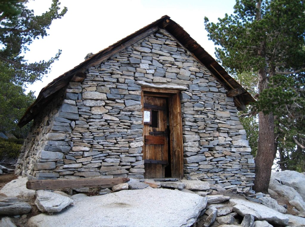
The Stone Hut is basically a storage place for supplies donated by fellow hikers. The hut is used as an emergency shelter and it is up to all those who come here to take care of it. There are clear instructions to tightly close the cabinets, in order to keep mice out, in case you take or donate something. Moreover, the same goes for the main door, visitors are requested to latch it shut when leaving to keep it safe for other people.
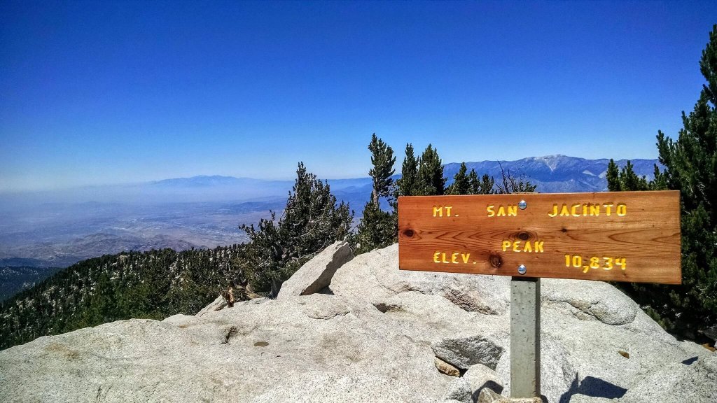
The Summit
You should head west from the stone hut to reach the summit. You will have to climb some boulders to reach to it, but all is worth it. The views are truly spectacular, so do take your time to soak it all in! You will be able to see the San Gorgonio Mountain and the famous Coachella Valley from up here.
Back Down
Retrace your steps on the way down to reach back to trailhead.